White Iron Chain Of Lakes Association

News & Updates Blog
Aug
22

Governor Dayton’s Water Quality Town Hall Meeting to Be Held in Ely

Joined by environmental advocates, lawmakers, and concerned Minnesotans for Water Action Day at the Minnesota State Capitol, Governor Mark Dayton announced a series of Water Quality Town Hall meetings beginning in late July. The town halls offer Minnesotans an opportunity to discuss the water quality challenges facing their communities and our state, learn from experts, and engage with policymakers. The town hall meetings build on the momentum from Governor Dayton’s “25 by 25” Water Quality goal proposal, announced earlier this year.

Town hall meetings have been scheduled in communities across Minnesota.

Make sure to attend the Water Quality Town Hall in Ely.

Ely – Water Quality Town Hall

Tuesday, September 12, 2017

Grand Ely Lodge, 400 North Pioneer Road

Registration opens at 5:30 p.m.

Northeast Minnesota Information Packet

Ely Town Hall on Facebook

Continue reading
  1857 Hits
Tags:
Aug
13

August 2017 Public Meeting of the International Rainy-Lake of the Woods Watershed Board in Tower, MN

The International Rainy-Lake of the Woods Watershed Board invites you to attend a presentation by the Board, meet Board members and staff, ask questions, and express concerns. 

  • TUESDAY, AUGUST 15, 2017 – 6:30pm-8:30pm Fortune Bay Resort Casino & Conference Centre 1430 Bois Forte Road, Tower, Minnesota

Imagine two countries sharing hundreds of lakes and rivers along their border without conflict. That is the mission of the International Joint Commission (IJC) which was established under the Boundary Waters Treaty of 1909 to help the United States and Canada prevent and resolve disputes over the use of the waters the two countries share. Its responsibilities included investigating and reporting on issues of concern when asked by the governments of the two countries. The IJC has created boards to watch over 12 watersheds shared by the two countries, including the Rainy-Lake of the Woods Watershed. 

The public meeting is an opportunity to both learn more about the Rainy-Lake of the Woods Watershed Board and to provide input about concerns people have about both water quantity and water quality issues in the watershed. Normally the Board meets in International Falls or Kenora Ontario, so this is a chance for them to learn and hear more about what is happening here in the headwaters of the watershed. Unlike Las Vegas, what happens here does not stay here, but flows eventually to those border waters between Minnesota and Canada. The Board needs to hear about your problems and hopes for this area.

Further information about the IJC may be found at; http://www.ijc.org/en_/ 

Further information about the Watershed Board may be found at: http://www.ijc.org/en_/Rainy_River_Basin and http://ijc.org/en_/RLWWB.

Continue reading
  1954 Hits
Tags:
Aug
05

USFS Prescribed Burn; 8-5-17 Update

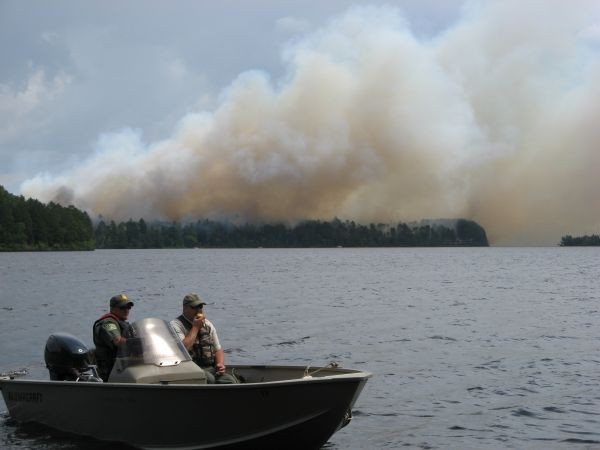
The USFS conducted a Prescribed Burn on White Iron Lake yesterday August 4th.  The purpose of the prescribed burn was fuel reduction and ecosystem management.

(See 8/4/17 WICOLA Latest News Article for details)

The USFS reports that the fire behavior was moderate which was what fire managers planned. Fuels were not too wet nor too dry and there was good consumption in most of the unit. In some portions the fire left a mosaic of burned and unburned fuels.

Tomorrow through the weekend, some pockets of fuels will be ignited, especially along the north line. Hose lays and sprinklers will be used and crews will be monitoring fire activity. Visitors and residents will see and smell smoke through the weekend. A northwest wind is predicted for tomorrow pushing most of the smoke to the southeast. The north line will be patrolled until there is a soaking rain or fire behavior is minimal.

Continue reading
  1669 Hits
Tags:
Aug
04

USFS Prescribed Burn; 8-4-17

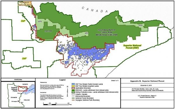
The USFS is planning a Prescribed Burn on White Iron Lake today (8-4-17).  Below is a map of the area and a message from the USFS discussing the planned burn.  Please contact the USFS if you have any questions or need more information. 

Rebecca Manlove

Information Assistant

Superior National Forest, Kawishiwi Ranger District

p: 218-365-2093

This email address is being protected from spambots. You need JavaScript enabled to view it.

1393 Highway 169

Ely, MN 55731

www.fs.fed.us


United States Department of Agriculture

Date Issued:  August 3, 2017

Anticipated Date of Ignition: Friday, August 4, 2017

Prescribed Fire Information: 218-365-2093

Location:  T62N R12W S13 and T62N R11W S18 In northeastern Minnesota, in St. Louis County on the Kawishiwi Ranger District on the Superior National Forest (Map above.) This 82 acre unit is located at the tip of the peninsula at the end of Ring Rock Road on the southeastern shore of White Iron Lake.

Description:

The purpose of the prescribed fire is fuel reduction and ecosystem management. Fire managers want to burn the White Iron Unit after the fuels dry slightly from recent rain but not so long afterward that all the fuels on the landscape dry out. The ideal condition is a northerly wind to blow smoke and embers away from nearby homes. Enough crews will be on duty to both accomplish the prescribed fire and to be on stand-by for response to wildfires in case they happen at the same time.

One reason a summer burn is ideal is that older pines have more water. We've been measuring the moisture level in the needles of the balsam, Jack pine, white pine, and red pine. The pines have plenty of water to buffer themselves from the heat of a fire. Historically, fires burned in summer when there is more lightning.  These trees co-evolved with fire, so most can handle the heat of a surface fire. Burning will protect the peninsula from stand-replacing fire and reduce the germination of balsam fir. Fire kills the balsam seeds in the soil. A summer burn is within the prescription of the burn plan for this unit.

Resources:

· Firefighters crews will use hose lines and hand tools and work directly on the prescribed burn unit.

· Crews will use boats during the ignition phase as well as holding operations because the unit is on a peninsula. Additional crews will remain on stand-by in case wildfire breaks out in other locations.

· Sprinkler hoses will be set up along the northern line. Balsam was removed and brush piles were burned last spring.

· Many nearby landowners have created defensible space using Firewise Standards around their structures.

Closures:

·There will be no closures of entry points, campsites or portages within the Boundary Waters Canoe Area Wilderness (BWCAW).

· Depending on winds, residents and visitors on White Iron and Birch Lakes, the South Kawishiwi River, and the Spruce Road may see and smell smoke. 

Continue reading
  2451 Hits
Tags:
Aug
03

Blueberry Festival; “Guess the Number of Rusty Crayfish” Winner

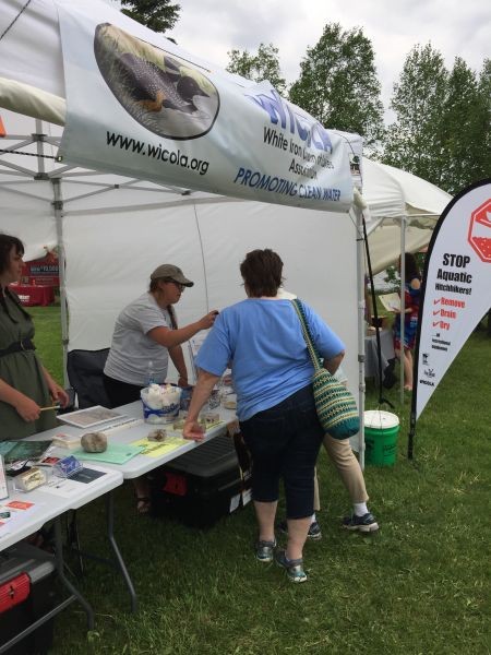
Volunteers from WICOLA and Partner Organizations spoke with hundreds of visitors at the 2017 Annual Blueberry Festival. Visitors to the booth welcomed the information provided about the spread and prevention of aquatic invasive species, and water monitoring in WICOL and surrounding lakes throughout the watershed.

Part of the education on Rusty Crawfish involved identification of this invasive species with the opportunity to guess the number of Rusty Crayfish in a two quart bottle. This year’s winner is Lauren, a Wisconsin resident who spends summers in Ely. Lauren was the only entry with the correct number of crayfish- 112. The prize was a Kubb Set made by a WICOLA member. For those that may not be familiar, Kubb is a lawn game where the objective is to knock over wooden blocks (kubbs) by throwing wooden batons at them. Kubb can be described as a combination of bowling and horseshoes. The alleged Viking origin of the game has led some players and kubb fans to nickname the game “Viking chess”.

Continue reading
  1952 Hits
Tags:
Jul
28

1854 Treaty Authority – Impact of Rusty Crayfish on Wild Rice

Note; Lakes included in this research study include Farm, Garden and White Iron.

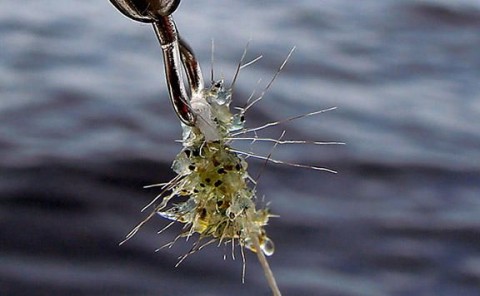
Orconectes rusticus (rusty crayfish) is the only confirmed species of invasive crayfish in the 1854 Ceded Territory in NE MN. Rusty crawfish prefer rocky substrate, but have been found to inhabit sand, silt, clay, and gravel. They prefer warmer temperatures, but can tolerate cool water and are usually found in shallow areas. Rusty crawfish do not possess an ability to burrow, and require clear and well- oxygenated water to survive.

 Rusty crawfish has been found to graze heavily on germinating aquatic vegetation, and are capable of displacing and reducing the diversity of native aquatic plants (aquatic plants). Introductions of Rusty crawfish have shown detrimental impacts on aquatic plant populations around the littoral zone of lake systems. In some instances, reductions of aquatic plant populations by as much as 80% have occurred.

The 1854 Treaty Authority has interest in the effects of Rusty crawfish on aquatic plant communities that produce native Zizania palustris (wild rice) within the 1854 Ceded Territory. Wild rice is a culturally significant plant that provides sustenance in many forms to the Bois Forte and Grand Portage Chippewa bands. Wild rice typically grows best in shallow depths of 1-3 feet in areas containing soft, organic bottoms. In mid-June, wild rice reaches the “floating-leaf” stage at which point wild rice lays flat on the surface of the water and can form dense leafy mats. In July, wild rice begins to emerge vertically and can stand out of the water up to 6-8 ft. tall. In August and September ripe seed can be harvested or will fall in the water to germinate the next year.

Wild rice populations have been observed to decline in some areas infested with Rusty crawfish, but whether this impact is directly related to an infestation is unknown. The 1854 Treaty Authority conducted a study from 2013 to 2016 testing for the potential impacts of Rusty crawfish on wild rice. From 2013-15 the study focused on if Rusty crawfish negatively impacts wild rice populations, and in 2016 the study addressed the questions of which stages of wild rice growth can Rusty crawfish affect, and if wild rice is a preferred food source.

The full report (16 pages) of the 1854 Treaty Authority wild rice/rusty crayfish project is now available on their web site at:

http://www.1854treatyauthority.org/images/1854-Technical-Report-17-08-Rusty-Crayfish-Report_3.pdf

Continue reading
  2576 Hits
Tags:
Jul
24

WICOLA at the Blueberry Festival; July 28-30th

Attending the Blueberry Festival?

Come by the WICOLA Booth (#172) to visit, check out the AIS (Aquatic Invasive Species) materials, and enter the “guess the number of Rusty Crayfish” contest to win a special prize. WICOLA members and representatives from partner organizations will be at the booth to answer questions, to provide updates on AIS in Northern MN and to share AIS prevention information.

Continue reading
  1737 Hits
Tags:
Jul
23

Who Needs a Rain Garden?

Rain Gardens are depressions in the Landscape that are often planted with native flowers, shrubs, and trees. These spaces allow storm water from impervious surfaces and snowmelt runoff to be captured, stored, and infiltrated into the landscape. Instead of flowing over the surface of the landscape and potentially causing erosion or transporting contaminants into our lakes, the water soaks into the ground. This process provides moisture to help support the plants in the garden, which in turn support the native insect and bird populations that depend on these plants for food and shelter.

Did you know…?

  • A rain Garden improves water quality and attracts a wide variety of butterflies, songbirds, and admirers to your landscape
  • There is much less long-term maintenance with a rain garden compared to a grass lawn
  • A rain garden can include flowers, grasses, trees, and shrubs
  • A well planned rain garden won’t have standing water in it for more than a day of two, and will not breed mosquitos or black flies
Continue reading
  1717 Hits
Tags:
Jul
18

Rainey River Watershed Restoration and Protection Strategy - WRAPS

The Rainy River-Headwaters Watershed lies in northeastern Minnesota and covers approximately 2,954 square miles or 1,890,689 acres. A total of 1,273 lakes (>10 acres) and 408 stream reaches reside within this watershed. Streams are generally small to moderate in channel size, short, and vary in gradient; many are direct tributaries to the many lakes in the watershed. The immaculate waters found within this watershed not only produce some of the highest quality fisheries in the state but also offer visitors many scenic and natural views. The most visited wilderness area (Boundary Waters Canoe Area) in the United States is located within this watershed, with water as a major focal point. Today over 99% of the Rainy River-Headwaters Watershed is undeveloped and utilized for timber production, hunting, fishing, hiking, and other recreational opportunities. Large tracts of public land exist within this watershed, including county land, national and state forests, wildlife management areas, scientific and natural areas, state parks, and a national park.

In 2014, the Minnesota Pollution Control Agency (MPCA) undertook an intensive watershed monitoring (IWM) effort of surface waters within the Rainy River-Headwaters Watershed. Sixty-two stream stations were sampled for biology at the outlets of variable sized subwatersheds. These locations included the mouth of the Ash, Bear Island, Black Duck, Cross, Dumbbell, Dunka, Island, Little Indian Sioux, Little Isabella, Shagawa, South Kawishiwi, and Stony rivers, as well as the upstream outlets of major tributaries, and the headwater outlets of smaller streams. Cook and Lake County Soil and Water Conservation Districts (SWCD) and Vermilion Community College completed stream water chemistry sampling at the outlets of 13 streams. In addition, the MPCA, Lake County SWCD, Natural Resources Research Institute, National Park Service, and local volunteers completed lake monitoring on 60 lakes. In 2016, a holistic approach was taken to assess all surface waterbodies within the Rainy River-Headwaters Watershed for support of aquatic life, recreation, and consumption (where sufficient data was available).

The full report (337 pages) of the Rainy River Headwaters WRAPS report is now available online at https://www.pca.state.mn.us/sites/default/files/wq-ws3-09030001b.pdf.

Want to know more about the WRAPS process and the significance for WICOLA?  See MPCA's Amy Mustonen's article in WICOLA's Summer 2017 Newsletter.

Continue reading
  2047 Hits
Tags:
Jul
12

Lake County Seeking Hazard Mitigation Ideas

Lake County requests residents input on the five-year update of our Hazard Mitigation Plan, through a public meeting on Tuesday, July 18 at 6pm in the Fall Lake Town Hall.

“The Hazard Mitigation Plan lists the greatest hazards to Lake County, and how we can prevent or reduce their impact to our residents,” said BJ Kohlstedt, Lake County Emergency Manager. “We use it to figure out where we can best put our time and money to be more prepared and resilient.”   

During the public meeting, recent disasters will be reviewed, along with what was done to respond and recover, and how to possibly mitigate future damages. We’ll look at changing hazard expectations due to technology and climate change, and brainstorm actions that we can take to lessen future impacts in our communities.   

Since our greatest hazard in Lake County has historically been wildfires, the Community Wildfire Protection Plan will also be reviewed during the meeting. Both plans are available on the Lake County website under Emergency Management Department / Plans at:

http://www.co.lake.mn.us/departments/emergency_management/plans.php

If you can’t make the meetings, there are two public input surveys on the website under the Hazard Mitigation Plan link. We appreciate any feedback.

“This Plan is built from public knowledge and input,” said Kohlstedt. “We need your good ideas.” 

Contact: BJ Kohlstedt, Director – Lake County Emergency Management,

218-220-7810 or This email address is being protected from spambots. You need JavaScript enabled to view it..

Continue reading
  1695 Hits
Tags:
Jul
11

Forest Service seeking comments on future mining projects in the BWCAW watershed

Update to the Jan 18th WICOLA Latest News Post

The U.S. Forest Service made formal its proposal to call a two-year timeout on new mining around the edges of the Boundary Waters Canoe Area Wilderness.

The Forest Service plan, announced in December at the same time the federal government denied critical mineral leases to the Twin Metals copper project near Ely, will prevent any new mining projects or exploration on 234,328 acres in the Superior National Forest.

The proposal was published in the Federal Register on January 13, 2017

The Forest Service says the land and water immediately around the BWCAW may be too fragile to withstand potential contamination from copper-nickel mining.

This January 13th action triggers public comment period on agency’s plan to withdraw the land from the federal minerals leasing program.

The Forest Service and the Department of Interior are seeking comments from the public to help them decide on whether they should extend the current two-year moratorium on this dangerous type of mining in the Wilderness watershed for the next 20 years.

The Forest Service states that “Comments are most useful if they refer to an activity or mitigation rather than stated values. For example comments such as ‘This area is used by many people for gathering berries’ can help us inform the analysis more than the comment ‘I do/don’t think you should withdraw federal mineral leases”.

In addition to the public meeting held March 16th at the Duluth Entertainment Convention Center, the U.S. Forest Service has announced they will be holding two additional public meetings on the proposed long-term protections for the watershed of the Boundary Waters and Voyageurs National Park.

  • LISTENING SESSION - SAINT PAUL
    Tuesday, July 18, 2017
    Saint Paul RiverCentre, Exhibit Hall A
    5:00 p.m. - 7:30 p.m. (doors open at 4:30 p.m.)
    Map & Directions »
  • LISTENING SESSION - VIRGINIA
    Tuesday, July 25, 2017
    Virginia High School, Auditorium
    5:00 p.m. - 7:30 p.m. (doors open at 4:30 p.m.)
    Map & Directions »

In addition to the public meetings, comments can be sent to (deadline is August 11, 2017):

For more information, go to www.fs.usda.gov/projects/superior/landmanagement/projects and click on “developing proposal.”

Continue reading
  1772 Hits
Tags:
Jun
28

Blue-green algae: If in doubt, stay out

By Minnesota Pollution Control Agency

Summer is here, and while water enthusiasts and pets enjoy swimming and boating when the weather is calm and sunny, these conditions are also perfect for growing blue-green algae, which can be harmful to both people and animals.

Last summer, blue-green algal blooms were reported in lakes across the state, from near the Iowa border all the way to the Canadian border. The Minnesota Pollution Control Agency (MPCA) and Minnesota Department of Health (MDH) staff jointly investigated two reported human illnesses and multiple dog deaths following exposure to blue-green algae. Blooms typically begin to form this month as the weather heats up, but with the mild spring weather this year, blooms have already been spotted.

People and pets at risk

The appearance of a blue-green algal bloom and the unpleasant smell that occasionally accompanies a bloom typically keep most people out of the water. However, people can become sick after they swim, boat, water ski, or bathe in water that has toxic blue-green algae. During these activities, people are exposed to the toxins by swallowing or having skin contact with water or by breathing in tiny droplets of water in the air. “In most people, symptoms are mild and may include vomiting, diarrhea, rash, eye irritation, cough, sore throat, and headache,” says MDH Epidemiologist Stephanie Gretsch.

Dogs are at particular risk, as they are more likely to wade in the areas of a lake where algal scum accumulates. Dogs are usually exposed to larger amounts of toxins from algae because they tend to swallow more water than humans while swimming, especially when retrieving toys from the water. They also lick their coats upon leaving the water, swallowing any algae that may be on their fur. Dogs exposed to blue-green algae can experience symptoms such as vomiting, diarrhea, rash, difficulty breathing, general weakness, liver failure, and seizures. If your dog experiences any of these symptoms after visiting a lake, seek veterinary care immediately. In the worst cases, blue-green algae exposure can cause death.

Tips to protect yourself and your pets

Not all blue-green algae are toxic, but there is no way to tell whether a bloom is toxic by looking at it. Harmful blooms often look like pea soup, green paint, or floating mats of scum and sometimes have a bad smell. However, harmful blooms aren’t always large and dense and can sometimes cover small portions of the lake with little visible algae present. Before you or your children or pets enter the water, take a closer look at the lake and check for algae in the water or on shore to help determine if a bloom recently happened.

“If it looks and smells bad, don’t take a chance. We usually tell people: If in doubt, stay out,” says Pam Anderson, MPCA Water Quality Monitoring Supervisor. “If you’re not sure, it’s best for people and pets to stay out of the water.” If you do come into contact with blue-green algae, wash off with fresh water immediately, paying special attention to the areas your swim suit covers. Rinse off pets with fresh water if you think they swam in water where blue-green algae were present.

Addressing the algae problem

There are currently no short-term solutions to fix a blue-green algal bloom. Once a bloom occurs, the only option is to wait for the weather to change to disrupt the algae’s growth. “With intermittent rain, followed by high temperatures, blue-green algal blooms will be common on many Minnesota lakes this summer,” Anderson says.

The key to solving algae problems is to improve overall water quality by reducing how much phosphorus gets into lakes. Phosphorus is a nutrient that encourages plant growth, and it is present in soil and plants. Runoff from urban and agricultural land contains phosphorus. Excess phosphorus in lakes provides the food necessary to produce algal blooms. Aside from limiting applications of fertilizers that contain phosphorus, homeowners can help protect our lakes by sweeping up lawn clippings and soil off sidewalks and pavement, and cleaning up pet waste, so that rain storms don’t wash the material into nearby lakes and rivers.

More information on blue-green algae, including how to report a possible human or animal illness, is available on the MDH Harmful Algal Blooms website.

Broadcast version

The Minnesota Pollution Control Agency and the Minnesota Department of Health are advising the public to stay out of algae-laden water. This year’s mild spring weather has created ideal conditions for algal blooms.

Certain species of blue-green algae contain potent toxins that can quickly become deadly to both people and animals. Keep pets and children away from waters with a pea soup or green paint appearance. Water may also have a foul odor. Symptoms can include vomiting, diarrhea, headache, eye irritation, and seizures. If you or your pets experience these symptoms, seek medical or veterinary assistance immediately.

Continue reading
  2079 Hits
Tags:
Jun
14

WICOLA and The Great American Canoe Festival!

The Great American Canoe Festival was held at Ely’s Semers Beach on June 10th through 11th 2017.

We wish to extend our appreciation to the many people who took the time to stop by the WICOLA Booth to learn more about the WICOLA Organization as well as learn more about Aquatic Invasive Species, the Citizen Sentry Program, and methods to prevent the spread of AIS into the White Iron Chain of Lakes. During the festival, WICOLA distributed Aquatic Invasive Species information to more than 140 individuals who stopped by the WICOLA Booth.

For additional information on AIS, click on the “Educational Tab” on the WICOLA Homepage and then “Aquatic Invasive Species”.


Continue reading
  1629 Hits
Tags:
Jun
13

Ely AIS Decontamination Station

Please Help Protect Our Waters from Aquatic Invasive Species (AIS).

The methods for preventing the spread of AIS are simple and do not take much time.  These invasive plants and animals “hitch a ride” on our boats, trailers, jet skis, fishing gear, and other recreational gear.  Cleaning this equipment properly every time before transporting it is the best preventive measure for stopping the spread of AIS.

Specialized decontamination stations in the Ely area (3 in total) are now available for residents and non-residents free of charge.

The decontamination station closest to the White Iron Chain is located at the Ely Chamber of Commerce parking lot (intersection of Hwy 169 and Hwy 1, Ely, MN 55731). The process takes just 7 to 10 minutes.

WICOLA strongly encourages members to decontaminate their boats when moving lake-to-lake and to also encourage their guests bringing boats to our Chain of Lakes to also take advantage of this decontamination service.

The hours of operation for the Ely Chamber of Commerce decontamination station are;

Friday thru Sunday - 9am-5pm (Also open July 3-4, and Labor Day)

For additional information on AIS, click on the “Educational Tab” on the WICOLA Homepage and then “Aquatic Invasive Species”.

Continue reading
  2101 Hits
Tags:
Jun
05

Living with Fire - FREE one-day informational workshop

Saturday, July 8th  •  8 am–5pm

Vermilion Community College (Classroom 104)

Attend this FREE one-day informational workshop designed for seasonal and permanent residents and visitors to our area. Understand why we should care about wildfire and what steps we can take to live safely in a fi re dependent environment.

Includes fire ecology and behavior, history of fire in Ely area, how to make your home more resilient to wildfire, evacuation planning and ways to create a more healthy forest environment. Workshops given by USFS wildfire personnel, MN DNR Firewise specialist, County Emergency managers, local firefighting professionals and the Lakes States project coordinator from the Forest Stewards Guild. Afternoon breakout demonstration tours. Lunch provided with kids activities.  Register for a Free Prize given away at the end of the day!

For more information and to register visit https://tinyurl.com/elylivingwithfire or contact Gloria Erickson at This email address is being protected from spambots. You need JavaScript enabled to view it. or 218-365-0878

8:00–8:30 Registration for tours and Free Prize! Coffee and morning snacks

8:30–9:15 Fire Ecology and Behavior Gus Smith, USFS Kawishiwi District Ranger History of Fire Ely Area Timo Rovo, USFS West Zone FMO

9:30–10:15 Fuels Reduction Basics and Strategies Jeffery Jackson, DNR NE Firewise Specialist

10:30–11:15 Living in a Fire Environment Directors of Emergency Management— BJ Kohlstedt, Lake County Dewey Johnson, St. Louis County Fire Chief: Ted Krueger Morse/Fall Lake Townships; Engine Captain USFS Wildland Fire Suppression: Tom Roach Evacuation Planning— Personal & Neighborhood wide Fire Chief: Larry McCray Eagle’s Nest Township

11:30–12:15 Forest Stewards Guild: Lakes States Project Coordinator— Michael Lynch

12:30–1:15 Lunch: Provided with donation as a fundraiser for local youth Vendor Exhibits! Activities for the Kids! Meet Smokey Bear! Fire Trucks, Wood Chipper and More!

1:30–3:30 Choose one Breakout Tour (Bring water bottle, weather appropriate gear and sturdy walking shoes/boots)

1) Firewise Best Practices Demonstration around home structure and beyond

2) Incident Command Scenario of the Hwy 1 Fire

3) Tours of Fuel Reduction Sites: Hand thinning, machine thinning and prescribed burn site

4) Sim Table (www.simtable.com) Wildfire Scenario

4:00–4:45 Wrap up Panel Discussion. Drawing for Free Prize!!!!!

Continue reading
  1793 Hits
Tags:
May
10

Removing lake plants could require a permit

Lakeshore property owners are reminded that the Minnesota DNR oversees activity on both the shoreline as well as in the water. For additional information, click on the “Educational Tab” on the WICOLA Homepage and then “Shoreline Management”.

By Minnesota DNR

Lakeshore property owners are reminded that a permit may be required to remove aquatic plants. 

“We remind folks each year that aquatic plants are essential to healthy lake ecosystems and property owners who want to remove them should check the regulations to see if they need a permit,” said Steve Enger, supervisor of the aquatic plant management program for the Minnesota Department of Natural Resources.

Aquatic plants provide food and shelter for fish, ducks and other wildlife. They stabilize the lake bottom, which helps maintain water clarity. These plants also protect shorelines from erosion by absorbing energy from waves and ice.

Property owners who want to remove aquatic plants with devices that create strong water currents need to know that such devices are illegal to use in a way that uproots plants, moves sediment or excavates the lake bottom.

Specific regulations govern what situations require permits for aquatic plant removal. Aquatic plant regulations and a guide to aquatic plants can be found on the aquatic plant regulations page, or by calling 651-296-6157 or 888-646-6367. To apply for a permit, visit the DNR’s permitting and reporting system webpage.

Continue reading
  1558 Hits
Tags:
May
09

Need Information on Lake Water Levels?

Minnesota Power operates Birch and Garden Lake Reservoirs’ water levels to maintain target parameters throughout the year as required by a Federal Energy Regulatory Commission (FERC) License. To learn more about these operating objectives, click on the “Educational Tab” on the WICOLA Homepage and then “Lake / Reservoir Levels”.

To view current water level elevations, flow, and conditions, please check the Minnesota Power webpage at;

http://web15.mnpower.com/web/public/Hydro/ShorelandTraditions/Levels.html

And the USGS stream flow report covering the inflow to Birch Lake Reservoir at;

http://waterdata.usgs.gov/mn/nwis/uv/?site_no=05125000&PARAmeter_cd=00065,00060

What to look for on the Minnesota Power Webpage

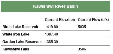
The Kawishiwi River Basin Chart includes the current Lake and Lake Reservoir Elevations for Birch, White Iron and Garden Lakes. The Chart also includes the Current Flow from the Birch Lake Reservoir into White Iron and the Flow from Garden to Fall Lake at Kawishiwi Falls.

The Garden Lake and Birch Lake Operating Band Charts can also be found on this page on the lower left corner under the title Kawishiwi River Basin Information. These charts graph the “Target” lake elevations as well as the “Upper” and “Lower” Operating Bands. These charts can be used along with the “Current Elevations Data” to help you determine where water levels are forecasted to be and how that might affect your shoreline and dock positioning.

Continue reading
  1764 Hits
Tags:
May
04

Aquatic Invasive Species Citizen Sentry Program

Join your friends and neighbors as we learn how to monitor our favorite waters!  Much like our ‘rusty crayfish trappers’, WICOLA wants to help you learn how to identify other invasive species and keep an eye on our beautiful chain of lakes.

Despite efforts on the part of numerous state and local agencies, current monitoring efforts are outmatched by the sheer size and number of lakes in Minnesota. In order to prevent additional Aquatic invasive species (AIS) from establishing on lakes in the area and to track the status of already infested lakes, WICOLA is sponsoring a citizen science monitoring education program. This program aims to narrow the monitoring gap by training citizen monitors as ‘sentries’.  By keeping an eye on an area they know well, a sentry is well poised to recognize when the health of their lake is changing. Sentries will be given a field guide and training administered by Lake County to aid identification and surveying. Data collected by volunteers will be passed along to Lake County Soil & Water Conservation District and infestations will also be reported to the MNDNR.

Trainings for citizen monitors, structured as a session to learn more about identifying aquatic plants and animals, will be held at a few different lakes in the Ely Area:

June 10th at Shagawa Lake- part of the Great American Canoe Festival offerings

June 14th at Vermilion Lake

June 24th at Farm Lake

July 8th at Burntside Lake

Identification sessions will run from 9am-12:30pm and include classroom and lakeside training.  A light breakfast is included.  WICOLA is providing these classes to you at no charge as part of a grant received from Lake County to support AIS education.   Please consider filling out and sending in the attached registration form; 2017-CitizenSentryRegistration-3.pdf 

If you have questions, please contact Mary Setterholm at;

612-741-8761 or This email address is being protected from spambots. You need JavaScript enabled to view it..

Spread the word, not the species!

Continue reading
  1610 Hits
Tags:
May
03

Governor Dayton Announces Ten Water Quality Town Hall Meetings to Be Held Across Minnesota

Joined by environmental advocates, lawmakers, and concerned Minnesotans for Water Action Day at the Minnesota State Capitol, Governor Mark Dayton today announced a series of Water Quality Town Hall meetings beginning in late July. The town halls will offer Minnesotans an opportunity to discuss the water quality challenges facing their communities and our state, learn from experts, and engage with policymakers. The town hall meetings build on the momentum from Governor Dayton’s “25 by 25” Water Quality goal proposal, announced earlier this year.

Town hall meetings have been scheduled in communities across Minnesota. Additional scheduling details will be made available ahead of the events.

Make sure to Mark Your Calendars to Save the Date and attend the Water Quality Town Hall this Fall in Ely.

Ely – Water Quality Town Hall

Tuesday, September 12, 2017

For additional information on Governor Dayton’s Water Quality Town Hall Meetings;

https://mn.gov/governor/blog/?id=290535

Continue reading
  1446 Hits
Tags:
Apr
17

Wildfire Prevention Week April 16-22

By Minnesota DNR April 16, 2007

To increase awareness of outdoor wildfire hazards, the Minnesota Department of Natural Resources has announced that April 16-22 is Wildfire Prevention Week. Minnesotans are asked to be thoughtful about how and when they use fire.

The DNR has initiated spring burning restrictions to reduce the number of unintended fires. A burning permit is required to burn vegetative material unless there is at least 3 inches of snow on the ground. The DNR or local governments may also restrict burning if weather conditions warrant.

Visit the DNR’s statewide fire danger and current burning restriction webpage before starting a fire. Also check local weather conditions.

Visit the Wildfire Prevention webpage to learn more about wildfire prevention.

Most wildfires in Minnesota occur in the spring. Last year’s dry vegetation can quickly catch fire between the time snow has melted and plants or grasses green up. Fires escaping a debris burn is the number-one cause of wildfires. Campfires escaping the fire ring on dry, windy days is another important cause of wildfires.

“The DNR is already fighting wildfires thanks to the mild winter and early spring,” said Linda Gormanson, DNR burning permits coordinator. “Dead or dormant vegetation can easily catch fire since we’ve had little precipitation so far this spring.”

Because escaped debris burning fires are the biggest cause of wildfires in Minnesota, Gormanson recommends mulching or composting vegetative debris to avoid these fires in the first place. If plans include a campfire, Gormanson said clear the area around the campfire and keep the fire to less than 3 feet in diameter and height. Keep a shovel and water on hand, watch the campfire continuously and make sure it is completely out before leaving.

So far this year, 455 fires have burned 1,238 acres.  On average each year, Minnesota fire agencies respond to 1,500 wildfires that burn over 42,000 acres at a cost of tens of millions of dollars.

Continue reading
  1504 Hits
Tags: